
Authors: Andrew Plowright
License: GPL 3
The ForestTools R package offers functions to analyze remotely sensed forest data.
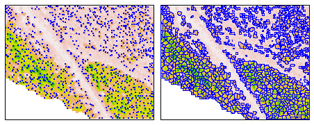
Individual trees can be detected and delineated using a combination of the variable window filter (vwf) and marker-controlled segmentation (mcws) algorithms, both of which are applied to a rasterized canopy height model (CHM). CHMs are typically derived from aerial LiDAR or photogrammetric point clouds.
Grey-level co-occurrence matrices (GLCMs) and their associated statistics can be computed for individual trees using a single-band image and a segment raster (which can be produced using mcws). These metrics can be used to characterize and classify trees.
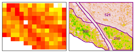
The height and count of treetops can be summarized within a grid or within user-defined geographical areas using sp_summarise.
This library implements techniques developed in the following studies:
The following is a non-exhaustive list of research papers that use the ForestTools library. Several of these studies discuss topics such as algorithm parameterization, and may be informative for users of this library.
Potential for Individual Tree Monitoring in Ponderosa Pine-Dominated Forests Using Unmanned Aerial System Structure from Motion Point Clouds by Creasy, M. B., Tinkham, W. T., Hoffman, C. M., & Vogeler, J. C. (2021)
Assessment of Above-Ground Carbon Storage by Urban Trees Using LiDAR Data: The Case of a University Campus by Gülçin, D., & van den Bosch, C. C. K. (2021)
Influence of Agisoft Metashape Parameters on UAS Structure from Motion Individual Tree Detection from Canopy Height Models by Tinkham, W. T., & Swayze, N. C. (2021)
Ground-penetrating Radar as Phenotyping Tool for Characterizing Intraspecific Variability in Root Traits of Pinus Halepensis by Lombardi, E., Ferrio, J. P., Rodríguez-Robles, U., de Dios, V. R., & Voltas, J. (2021)
Bridging the genotype–phenotype gap for a Mediterranean pine by semi‐automatic crown identification and multispectral imagery by Santini, F., Kefauver, S. C., Araus, J. L., Resco de Dios, V., Martín García, S., Grivet, D., & Voltas, J. (2021)
Tracking the rates and mechanisms of canopy damage and recovery following Hurricane Maria using multitemporal lidar data by Leitold, V., Morton, D. C., Martinuzzi, S., Paynter, I., Uriarte, M., Keller, M., … & González, G. (2021)
Cross-scale interaction of host tree size and climatic water deficit governs bark beetle-induced tree mortality by Koontz, M. J., Latimer, A. M., Mortenson, L. A., Fettig, C. J., & North, M. P. (2021)
The wildlife‐livestock interface on extensive free‐ranging pig farms in central Spain during the “montanera” period by Triguero‐Ocaña, R., Laguna, E., Jiménez‐Ruiz, S., Fernández‐López, J., García‐Bocanegra, I., Barasona, J. Á., … & Acevedo, P. (2020)
Supporting Assessment of Forest Burned Areas by Aerial Photogrammetry: The Susa Valley (NW Italy) Fires of Autumn 2017 by De Petris, S., Momo, E. J., & Borgogno-Mondino, E. (2020)
Applying unmanned aerial vehicles (UAVs) to map shrubland structural attributes in northern Patagonia, Argentina by Gonzalez Musso, R. F., Oddi, F. J., Goldenberg, M. G., & Garibaldi, L. A. (2020)
Automated Canopy Delineation and Size Metrics Extraction for Strawberry Dry Weight Modeling Using Raster Analysis of High-Resolution Imagery by Abd-Elrahman, A., Guan, Z., Dalid, C., Whitaker, V., Britt, K., Wilkinson, B., & Gonzalez, A. (2020)
Northern Bobwhite Non‐Breeding Habitat Selection in a Longleaf Pine Woodland by Kroeger, A. J., DePerno, C. S., Harper, C. A., Rosche, S. B., & Moorman, C. E. (2020)
Evaluation of Features Derived from High-Resolution Multispectral Imagery and LiDAR Data for Object-Based Support Vector Machine Classification of Tree Species by Roffey, M., & Wang, J. (2020)
Mapping Species at an Individual-Tree Scale in a Temperate Forest, Using Sentinel-2 Images, Airborne Laser Scanning Data, and Random Forest Classification by Plakman, V., Janssen, T., Brouwer, N., & Veraverbeke, S. (2020)
High-resolution multisensor remote sensing to support date palm farm management by Mulley, M., Kooistra, L., & Bierens, L. (2019)
Quantifying canopy tree loss and gap recovery in tropical forests under low-intensity logging using VHR satellite imagery and airborne LiDAR by Dalagnol, R., Phillips, O. L., Gloor, E., Galvão, L. S., Wagner, F. H., Locks, C. J., & Aragão, L. E. (2019)
Forest inventory sensitivity to UAS-based image processing algorithms by Maturbongs, B., Wing, M. G., Strimbu, B., & Burnett, J. (2019)
Remote sensing pipeline for tree segmentation and classification in a mixed softwood and hardwood system by McMahon, C. A. (2019)
Tree height in tropical forest as measured by different ground, proximal, and remote sensing instruments, and impacts on above ground biomass estimates by Laurin, G. V., Ding, J., Disney, M., Bartholomeus, H., Herold, M., Papale, D., & Valentini, R. (2019)
Advances in the Derivation of Northeast Siberian Forest Metrics Using High-Resolution UAV-Based Photogrammetric Point Clouds by Brieger, F., Herzschuh, U., Pestryakova, L. A., Bookhagen, B., Zakharov, E. S., & Kruse, S. (2019)
Multi-scale Assessment of Northern Bobwhite and White-tailed Deer Habitat Selection in Longleaf Pine Woodlands by Kroeger, A. J. (2019)
Bayesian and classical machine learning methods: a comparison for tree species classification with LiDAR waveform signatures by Zhou, T., Popescu, S. C., Lawing, A. M., Eriksson, M., Strimbu, B. M., & Bürkner, P. C. (2018)
Underproductive agriculture aids connectivity in tropical forests by Evans, L. J., Goossens, B., & Asner, G. P. (2017)